Monday, July 30, 2012

One More Time! Winnemucca Lake: Mokelumne Wilderness

My college-aged stepson is visiting this week, so I stole him away from his friends and family and we headed to the hills.

The weather this time was beautiful, although many of the flowers I saw earlier this month are done blooming. We got to the trailhead at 8:30am and had almost the whole place to ourselves. When we were hiking back, the trail was more crowded.

We hung out at the lake a bit, wandering along the shore, since I did not get a chance to do that last time.


The Kid drinks more water than I do, so I got to bust out my nifty water filter and refill our bottles. The collapsible bucket was very nice for bringing water up from the shore to a flatter spot.
Since my First Need filter is set up for my Nalgene bottle, we just dumped my bottle into his and refilled mine.

And one final cheese-tastic shot


Thursday, July 19, 2012

Carson Pass to Winnemucca Lake: Mokelumne Wilderness


July 19th

I love hiking with the Sierra Club Seniors. They don't go so very fast and make lots of stops. The showstopping wildflowers on this hike made for many many stops.


And I found my own personal paparazza in the group, who thought the red shirt and blue bandana I was wearing (and my tendency to clown) made for great pictures. I'm not so sure. So that was more stops. Stops in stops while stopped.

Oh yeah, did I mention I hike in a skirt and LOUD gaiters?
STOP, already!

This is an easy hike and VERY VERY popular, even on a blustery weekday. One wag in our group declared that the crowded trail was due to the number of folks out of work and spending time hiking.

Lake Winnemucca


The weather was less than perfect (gusty winds and annoying rain showers) when we arrived, but we dug out all kinds of rain gear and set forth.

Most of the group

All I really know is that we went generally north to south on the way out and south to north on the way back. We took a little side trip to scenic Frog Lake.

Frog Lake. Think it's gonna rain?

Just after climbed out of Frog Lake, we saw this lake to the west. I think it was Woods Lake since I think it would have been difficult to see Caples lake from where we were. There was much debate. So. Just call this a landscape with a pretty lake of some name or other.


Part of the route to the lake is on the Pacific Crest Trail so we saw several pairs of PCT thru-hikers on our way into the lake. You can tell them because their packs are often large, they are cheerful, and quite tanned. One fellow said most of it was dirt. I suppose it may have been.

On the way back one of the leaders pointed out a geocache on the trail. My Personal Paparazza left a note on behalf of our group.


Gear-chat: (just use the power of Google if you want to know more).
I used my usual pack (the Molly Mac Pack) with the front pack deployed, which, when covered up by my Packa made me look somewhat like a pregnant waterbuffalo. But I stayed warm and dry so I didn't really care. The Gossamer Gear trekking poles stayed locked in place and I used them about half the time, where the trail was steeply down or rocky. I ended up wearing spandex tights over spandex shorts on the way back (I had goosebumps at lunch) and they fought with each other the whole way back. So I did the 'pants tug' dance many times. My Tilley hat stayed put, although one of the 25mph gusts used the hat to try to knock me over. My Innov8 shoes were perfect, as were my Dirty Girl Gaiters. I even saw another pair of DGG on the trail! I was thrilled!
I did not use my Caldera Cone to make tea at lunch, since we only took a 20 minute break.


As I usually do, I taped my feet to prevent blisters. No blisters! (I blister like nobody's business).
I use Kinesio tape on the areas where I tend to blister (outside of heels, side of big toe and inside of ball of foot).
All the stuff I use, and my feet taped with Kinesio tape
I go around the edges with Compound Tincture of Benzoin (making my feet kind of yellow in spots) to make the Micropore tape stick the edges down better.

Edges stuck down with strips of Micropore tape.
 It is necessary to end and begin the pieces of Kinesio tape on the top of one's foot, or they will just peel up when striding along and make the blister problem worse. I learned all of this from the excellent book "Fixing your Feet".

And this is a good idea, because ... ?

NO MORE pictures. I'll have to go all Russell Crowe on you.

Friday, July 6, 2012

Cardiac Hill: Auburn State Recreation Area


Friday, July 6th

About 3 miles, but what a 3 miles! 1000 feet down, then turn around and 1000 feet up.

I decided, in advance of a backpack trip I had scheduled next weekend, to try out a Foothill Hikers (a Meetup group) early morning 'stroll' in the Auburn State Recreation Area. I'm glad I did, both because I determined that my whiplash recovery, although coming along wonderfully, is not quite far enough along to allow for a weekend of backpacking, and, of course, I got to check out a heck of a hill.


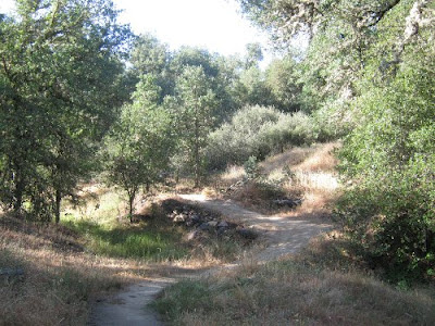
4 humans and 2 canines set off down a paved road, then down some gravel road, then on a little more paved road, then more gravel, until we could scramble down to the edge of the American River.


I sat on a rock, eating fresh cherries, and wondering if I was out of my mind. It was a lot of down.


Time to head back before it got too hot. Up up up up we went.


This is one of those trails that has switchbacks, but they are still quite steep. I was way way way in the back, managing to maintain a pace that kept me breathing deeply, but not quite gasping.

The dogs had jingles on. I could hear the dogs apparently directly over my head (they were just 3 switchbacks farther up than I). I could crane my neck upwards and see one of our party walking, seemingly, on the side of a hill. I knew if I could see one more switchback I'd see the rest of the group. The dogs kept jingling along.

I stopped taking pictures once we started up Cardiac Hill, because I was too busy sweating and panting and sweating and panting to bother getting the camera out.

Not panting, breathing heavily, that's it.

This trail has gotten a lot of use and in some places is so worn down or eroded that the sides of the trail are hip-high. Many rocks and tree roots to clamber over. Lots of poison oak. We neither saw nor heard any rattlers. I think I saw some fox scat.

Finally, we came up to basically parking-lot-elevation and followed an aqueduct back to the parking lot.


I knew I would be challenged by this hill, so I traveled light: water, firstaid, compass in a butt-pack; UnderArmor shirt, spandex exercise shorts, widebrimmed hat, and walking sticks. I also dug out my LOUD gaiters.


I'm glad I did because the trail was predictably dusty and the gaiters keep some dust out of my ventilated (ie: mesh) trailshoes and also keep out pebbles. And there were no ticks found on those blinding white shins!


Wednesday, June 6, 2012

Dave Moore Nature Area: Mother Lode field office, BLM

Wednesday, June 6th


Well, it has been a while, hasn't it?

Too much bike riding, not enough hiking.

The mile long loop trail in the nature area is a quick and easy 20 minute outdoor fix. I had it to myself this morning except for one jogger. And lots of bird song. And bushels of poison oak (the trail is nice and clear). Most of the trail is shaded with just a few areas without tree cover. The entrance to the nature area is right off of Highway 49, just west of Lotus, CA.

I was trying to make fancy with alignment and so on. I give up. Captions from here on out!

Sign at Highway 49

Road into parking area. Lots of parking here.

The trail is well constructed and well maintained, with many flat wide bridges over a stream.

One single-board bridge. If you want to get to the river and skip this 'bridge', start at the outhouse end of the loop trail (right side of parking lot)

The huge piles of dredged river rock (from mining in years past) have been turned into walls and trail-edging.
Other signs of mining in the form of a manmade ditch, now a ravine, absolutely packed with poison oak.
Several picnic areas with tables are available along the trail.
Sunlit switchbacks. This is a very easy trail. Super easy. Google "Dave Moore Nature Area" and you'll find the BLM site with everything you'd want to know about Dave Moore.

In common with other BLM properties along the South Fork American River: birdhouses.

Upstream on the South Fork American River

Downstream

What happened here? Brace for some mining equipment? Browridge of a submerged troll? Giant petrified hamburger?


Tuesday, April 3, 2012

Mormon Island Trailhead: Folsom Lake SRA


I felt the need to get outside (not on wheels) so I headed out for a very short walk with my arthritic dog from this trailhead. I posted about this area here, so today's mostly pictures.

She is really a nice dog. This is the most Cujo-like picture I've ever taken.

Looking down Mormon Island Dam

Spring! 

Plane coming in for a landing on Folsom Lake
I sat and stared out at the water for a while, content to just be. The Dog sniffed around, also presumably content.

Then we walked back to the street parking on Sophia.